North Texas Dust: Saharan Air Mass's Long Trek Explained

Welcome to your ultimate source for breaking news, trending updates, and in-depth stories from around the world. Whether it's politics, technology, entertainment, sports, or lifestyle, we bring you real-time updates that keep you informed and ahead of the curve.
Our team works tirelessly to ensure you never miss a moment. From the latest developments in global events to the most talked-about topics on social media, our news platform is designed to deliver accurate and timely information, all in one place.
Stay in the know and join thousands of readers who trust us for reliable, up-to-date content. Explore our expertly curated articles and dive deeper into the stories that matter to you. Visit Best Website now and be part of the conversation. Don't miss out on the headlines that shape our world!
Table of Contents
North Texas Dust: Saharan Air Mass's Long Trek Explained
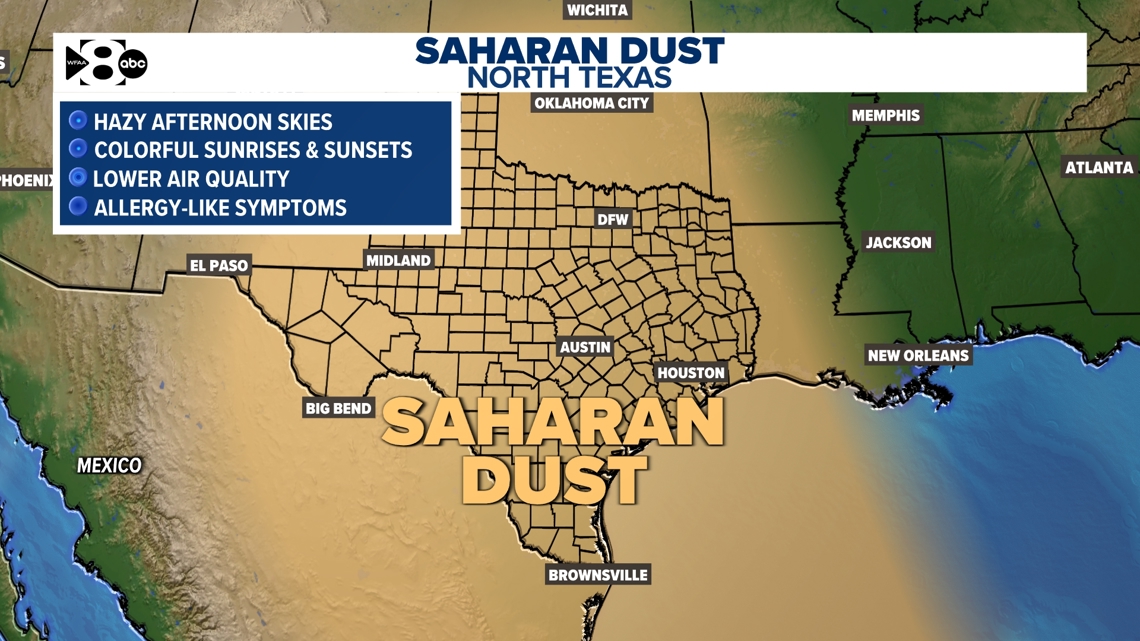
North Texas residents recently experienced a dramatic dust phenomenon, painting the skies a hazy orange and leaving a fine layer of dust on everything. This wasn't local dust; it was the result of a Saharan Air Layer (SAL) making its incredible journey across the Atlantic. This article delves into the science behind this fascinating meteorological event, explaining how a dust mass from the Sahara Desert can travel thousands of miles to impact North Texas weather.
Understanding the Saharan Air Layer (SAL)
The Saharan Air Layer is a massive body of dry, dusty air originating over the Sahara Desert in Africa. Driven by strong winds and high-pressure systems, this layer of air can extend several kilometers high and stretch for thousands of kilometers. It's characterized by extremely low humidity, high temperatures, and significant amounts of mineral dust particles. These dust particles are lifted into the atmosphere by strong winds and carried westward by the prevailing trade winds.
This isn't a new phenomenon. The SAL's transatlantic journey is a regular occurrence, especially during the late summer and early fall months (July through September). However, the intensity and visibility of the dust can vary from year to year.
The Journey Across the Atlantic: A Meteorological Marvel
The journey of the SAL across the Atlantic is a remarkable feat of atmospheric physics. The dust particles are transported aloft within the powerful easterly trade winds, often reaching altitudes of several thousand feet. This altitude allows the dust to bypass much of the lower-level moisture and precipitation that could otherwise wash it out.
As the SAL moves westward, it interacts with weather systems in the Atlantic Ocean. While some dust is lost through deposition or precipitation, a significant amount persists, eventually reaching the Caribbean islands and the southern United States.
Impact on North Texas Weather
The arrival of the SAL in North Texas typically leads to several noticeable effects:
- Reduced Air Quality: The high concentration of dust particles significantly reduces air quality, potentially exacerbating respiratory issues for sensitive individuals. Air quality alerts are frequently issued during these events.
- Hazier Skies: The dust particles scatter sunlight, leading to hazy, orange-tinged skies, significantly reducing visibility. Sunsets and sunrises often appear more vibrant and dramatic.
- Suppressed Tropical Cyclone Development: Ironically, the SAL can actually reduce the likelihood of hurricane formation in the Atlantic. The dry, dusty air inhibits the development of tropical cyclones by suppressing thunderstorm activity. .
- Slightly Higher Temperatures: While the dust can sometimes slightly reduce daytime temperatures, it also inhibits nighttime cooling leading to slightly warmer nights.
Preparing for Future SAL Events
While the Saharan Air Layer's journey is a natural process, understanding its impact is crucial. Staying informed about air quality alerts and taking precautions during periods of high dust concentration is essential, particularly for individuals with respiratory conditions. Check your local news and weather forecasts for updates on air quality and potential SAL impacts.
Conclusion:
The recent dust event in North Texas serves as a powerful reminder of the interconnectedness of our atmosphere and the far-reaching impacts of weather systems. The Saharan Air Layer's journey is a testament to the power of nature and highlights the importance of understanding and preparing for these infrequent, yet significant, meteorological occurrences. Staying informed and prepared is key to mitigating any potential health impacts associated with these events.

Thank you for visiting our website, your trusted source for the latest updates and in-depth coverage on North Texas Dust: Saharan Air Mass's Long Trek Explained. We're committed to keeping you informed with timely and accurate information to meet your curiosity and needs.
If you have any questions, suggestions, or feedback, we'd love to hear from you. Your insights are valuable to us and help us improve to serve you better. Feel free to reach out through our contact page.
Don't forget to bookmark our website and check back regularly for the latest headlines and trending topics. See you next time, and thank you for being part of our growing community!
Featured Posts
-
 Transfer News Arsenal Makes Bid For Gyokeres Sporting Cp Responds
May 30, 2025
 -
 Details Emerge Shawn Kemps Guilty Plea For Parking Lot Shooting Assault
May 30, 2025
 -
 The 2012 Western Conference Finals Key Trends Leading To The Thunders Finals Berth
May 30, 2025
 -
 Henrique Rocha Vitoria Historica Em Sua Primeira Participacao Em Roland Garros
May 30, 2025
 -
 6 Abc Memorial Day Feature Highlights Upper Dublins Young Residents
May 30, 2025
Latest Posts
-
 Will Djokovic Advance French Open Day 7 Predictions And Analysis
May 31, 2025
 -
 Resilient Pacers Respond How Indiana Plans To Bounce Back
May 31, 2025
 -
 Updated Mlb Power Rankings Week 9 Analyzing The Top Performers
May 31, 2025
 -
 Severe Penalties Announced Sec Cracks Down On Field Rushing With 500 000 Fines
May 31, 2025
 -
 Pittsburgh To Receive 7 5 Million In Water Line Improvements From Pa American Water
May 31, 2025
